


| Distance | 113.39 kms | 70.21 miles |
|---|---|---|
| Climbed | 1,020 meters | 3,346 feet |
| Ride time (hours) | 6.92 | - |
| Avg speed | 10.1 kph | - |
| Avg climb | 3% | - |
| Max grade | 17% | - |
| Distance | 27,129.45 kms | 16,857.17 miles |
|---|---|---|
| Climbed | 284,681 meters | 933,993 feet |
| Ride time (hours) | 1,925.25 | - |
Thursday, May 8th, 2014
It is a cold morning with frost on the tent and everything else I left outside last night. I'm in no rush to get going because I know the road is still going to be wet and muddy. I move the tent into the sun to dry it out, then set about making pancakes. I'm out of maple syrup but they still come out tasty (when I'm hungry enough, anything is good...).


When I'm out of things to do I break everything down and carry it out to the road. There are some patches of mud where I have to stop to clear out the mudguards and brakes, but all in all it is no where near as bad as my last brush with rain in this area. A few miles down the road a pickup truck coming in the other direction stops to tell me that the road is slick on the climbs ahead. They have 4-wheel drive but couldn't make it to the top; they are going to try again in a few hours. The woman in the passenger seat tells me she biked the Carretera Austral in Chile in 1989. A kindred spirit!


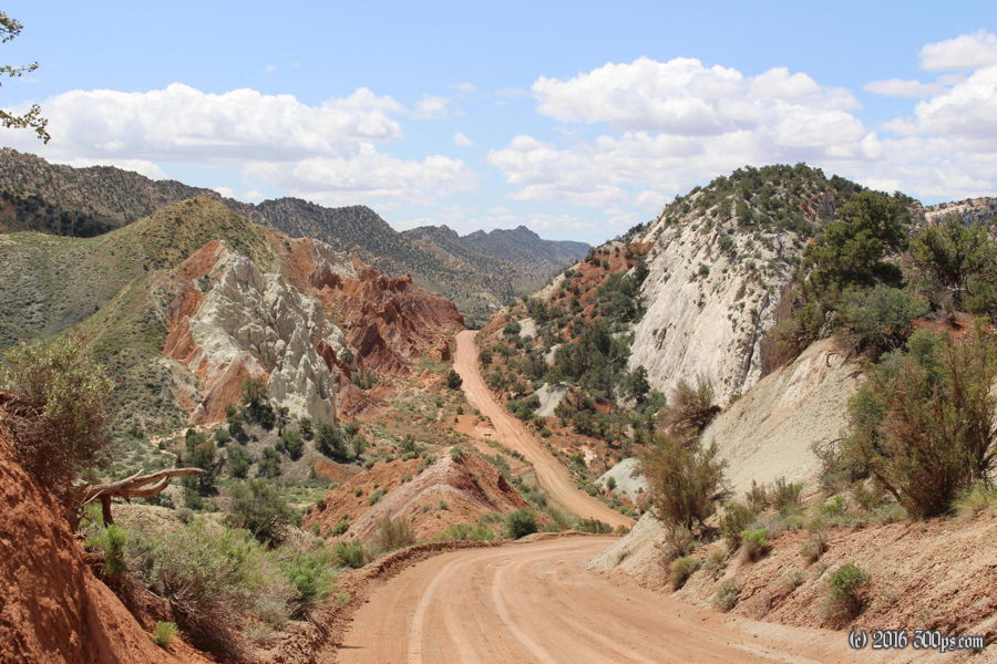
The climbs don't turn out to be so bad. I'm able to get up them with the occasional stop to clean out the brakes. The scenery higher up is fabulous, multicolored rock formations to the north and cedar-topped hills to the south. I run into the grader that the guy at the BLM office was telling me about. Fortunately he hasn't had time to do to much work yet today because the section he has softened up already is pretty tough for me to ride.


I stop at Grosvenor Arch to take a look, it is a natural double-arch rock formation that is very photogenic. I eat lunch at the picnic tables there presumably provided by BLM. By now it has warmed up and dried out. The road is bumpy but no more muddy sections for the rest of the day.


As the ride from here on out is more downhill than not, I do the 30 miles to highway 89 pretty quickly. Cottonwood Canyon has amazing scenery, it reminds me a lot of Paso Agua Negra in Chile where each turn reveals a new and weirder rock formation than the last. To the west are the Vermillion Cliffs, to the east the buttes of Escalante National Monument. There are long sections with undulating ridges of rock crested with blades of yellow slate, making the ensemble appear to be some kind massive prehistoric serpent frozen in time.


The road eventually exits the canyon to head across barren hills before reaching highway 89. It's tough riding with a crosswind from the southwest once the cover of the canyon wall is gone. I reach the highway: which way? West to Kanab, a day and a half of wind before any services? Or left to Page, a couple of hours with the wind at my back? I rob Peter to pay Paul and head to Page. I'm going to have to claw back this distance tomorrow but I don't care, I want a bed and a restaurant tonight.


The miles fly by with the wind behind me. I reach Glen Canyon Dam, stop to check it out, then climb up to Page where I get a motel room and stuff myself at a local restaurant. It is appreciably warmer tonight, I dropped about 2,500 feet of altitude today.


