


| Distance | 13.23 kms | 8.08 miles |
|---|---|---|
| Climbed | 148 meters | 486 feet |
| Ride time (hours) | 1.23 | - |
| Avg speed | 6.6 kph | - |
| Avg climb | 2% | - |
| Max grade | 10% | - |
| Distance | 27,016.06 kms | 16,786.96 miles |
|---|---|---|
| Climbed | 283,661 meters | 930,646 feet |
| Ride time (hours) | 1,918.33 | - |
Wednesday, May 7th, 2014
Miles pushing the bike: 0.2 (0.32 kilometer)
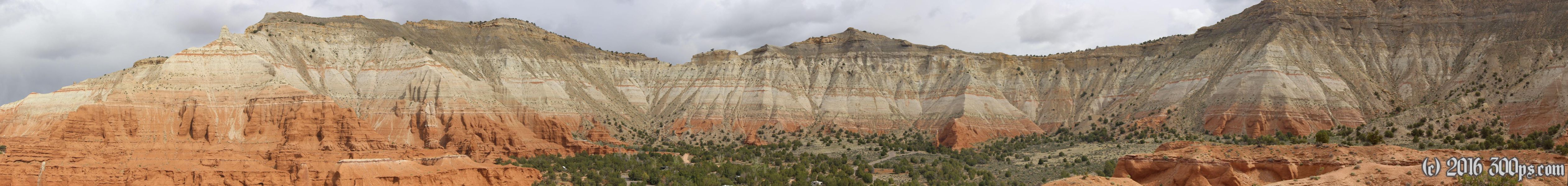
I make pancakes on the fire in the morning. The weather is still nice, some menacing clouds off to the south but plenty of sun. I go for a hike on "Angel's Palace" trail. It has good views looking back into the basin and of the rock formations on the mountains stretching away to the south.


While I'm up there the weather takes a turn for the worse: it starts sleeting. Why is it that precipitation since I've been in Utah always has to come in the form of sleet? As I'm walking back to the campsite I'm debating whether to stay here another day or go down Cottonwood Road. If I go down there I'm probably not going to make much progress due to the mud so I decide to stay in the park another day. However, when I arrive at my campsite I find people waiting to get in and set up, they have the site reserved for tonight. I take that as a sign from the Latter Day Saints that it's time to move on. My gear is half-packed anyways, I just take a gloriously long and hot shower before hitting the road.


There has been just enough precipitation to make the dirt road painful but not yet enough to turn the clay into Red Mud of Death. It won't take much more though. There are some ugly looking clouds rolling in, I decide to camp as soon as I find a decent spot, if not I could get stuck somewhere where there is no good place to camp if a downpour hits. After a few failed attempts I finally find a good spot in some rolling hills, set up the tent and take a nap.


At 4pm it rains and hails hard, complete with thunder and lightening. What is falling is ice, bigger than sleet, so I guess that makes it hail. It lasts about an hour and a half, then I get out of the tent to make a fire. It actually takes some work to get it going for a change. After dinner since I have the fire and I have the ice I make water for tomorrow.


