


| Distance | 60.28 kms | 37.28 miles |
|---|---|---|
| Climbed | 1,786 meters | 5,860 feet |
| Ride time (hours) | 7.74 | - |
| Avg speed | 7.9 kph | - |
| Avg climb | 4% | - |
| Max grade | 25% | - |
| Distance | 4,307.56 kms | 2,676.87 miles |
|---|---|---|
| Climbed | 44,607 meters | 146,348 feet |
| Ride time (hours) | 328.33 | - |
Tuesday, January 29th, 2013
When I got out on the road I realized that the pavement had ended for good. It would be ripio for the rest of the day. They are working on this section and from the looks of it there will be pavement soon. There were a couple of 14-15% grades early on that had me worried. Anything over 8% on ripio at this altitude is a killer. I was concerned that if the grades continued like that I wouldn't be able to make it over the pass.
It turned out that the grades toned down after I climbed into a long valley. There the problem became wind, which made the 3% grades feel like 8%. The wind kept on for the rest of the day except for when I was riding a long switchback back towards the east.
The altitude makes it all a struggle. Frequent stops and water breaks help. I just kept my head down and kept pedaling. I was cutting it too close on the food situation which meant that I had to get over the pass today. It was my motivation, otherwise I don't think I would have done it all today.
I stopped and made lunch in a stone shelter someone had made, perfect for blocking the wind. After I got back on the road a couple of guys from Córdoba in a VW stopped and asked about the trip. They had done a loop from Córdoba up through Paso Pircas Negras to La Serena, now back through Paso Agua Negra towards Córdoba. They were very enthusiastic about Paso Pircas Negras, saying it was the most beautiful place they had seen in Argentina. Might have to check that out then. I was planning on re-entering Argentina via Paso San Francisco but from what these guys said Pircas Negras would be better.
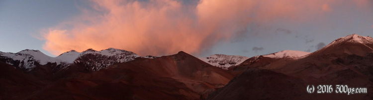
At 4,300 meters I started getting a headache. I was getting really tired as well, but I felt better than I had when doing the Paso Cristo Redentor in spite of the fact that this pass is much higher. The day wound down and still I wasn't at the top, I was worried if I would make it. It got really cold as soon as the sun disappeared behind the mountains. My VDO said 3 degrees but that temperature gauge always overestimates. I stopped to put on a heavier jacket and gloves.
Finally I reached the summit around 7pm. The signs at the top aren't very satisfying but my map says 4,780 meters, by far a personal best for me. I didn't stick around to enjoy the view as it was cold and I needed to drop some elevation before camping. The road on the Chilean side is complete shite: washboard with rocks and sand. I vibrated my way down to 4,000 meters, found a great place to camp but there was no hiding from the road; set up, ate, and in bed. I feel a little funny like a maybe a fever coming on...


