


| Distance | 70.00 kms | 43.50 miles |
|---|---|---|
| Climbed | 1,577 meters | 5,174 feet |
| Ride time (hours) | 8.01 | - |
| Avg speed | 8.6 kph | - |
| Avg climb | 5% | - |
| Max grade | 20% | - |
| Distance | 2,350.00 kms | 1,460.22 miles |
|---|---|---|
| Climbed | 26,870 meters | 88,156 feet |
| Ride time (hours) | 193.22 | - |
Monday, January 7th, 2013
The wind howled all night. During the middle of the night one of the tent stakes pulled up. I laid there in denial for about ten minutes before getting out to fix it. I woke up to find all my bags, which I keep in the atrium of the tent, covered in sand. It was a good thing I had tied my rain jacket over the vent at the back of the tent, it had a pile of sand on it that otherwise would have been inside. It was still blowing hard; no early morning wind break today like sometimes happens around here.
I inched my way up the river canyon for 14 kilometers until I reached the Argentine border control post. When I got there all of the officers came out to ask me questions about my trip. Later on I understood why: in the 34 kilometers I rode in Argentina to reach the border plus the 40 or so kilometers on the other side to reach the Chilean border control post I saw a total of 2 cars and a motorcycle. These border agents must be bored shitless. I asked them about their schedule, they said they work a 30 day rotation at the border then they have 5 days off before returning to the police station in the region that they normally work at. Since the crossing is only open in the summer, plus rotation of different gendarmerías from different cities, they only have work at the border once or twice in a career. They guy I was talking to most was from Chos Malal.
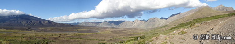
The ride up to the top of the Paso de Pichachén is tough but has amazing scenery. The road winds through a couple of valleys, at first along the river and then heads away towards the south. At one point there was a cattle gate blocking the road, tied with a rope and a wire. Pretty funny that on an "international pass" as they call it that I had to stop, untie a cattle gate, then tie it back up when I left. The cows on the other side were just looking at me like: "sooner or later one of these tourists is not going to know how to tie a knot, then we're free!" To reach the actual border there is a massive climb on loose sand and gravel up to about 2100 meters. I was skidding to a halt every 200 meters or so because of the depth of the loose sand. At least there was no traffic; I was free to weave across the road to pick any rut I wanted. The wind was blasting me the whole time as well. A couple of times it actually made me turn in circles: a gust would send me lurching in one direction, then I would have to keep going in that direction to keep my balance in the sand, end result I would go downhill for a second then turn back up in a circle. The last 100 meters were really bad, but there was no way I was going to walk after struggling all the way up this mountain (it probably would have been faster to walk this part).
The top has impressive views of the Sierra Velluda. The descent into Chile has the same loose sand and gravel ripio. It was pretty dangerous because the tires would just start sliding out from under me at seemingly random points. I took it slow but fell once anyways. The front tire just slid out on me and I went tumbling. I got up wanting to kick the bike but took a picture instead. The headwinds didn't let up at all. After the initial descent the road crosses a long valley before descending again down to the Chilean border post. They looked bored shitless as well. There was some initial consternation that the Argentines hadn't given me a copy of the immigration form but they looked it up on the computer and said it was ok. The customs guy asked me a bunch of questions about what I was carrying but didn't search anything.
After leaving the post the scenery really gets interesting. This valley is called La Valle de la Luna (Valley of the Moon). It's all black volcanic sand and rock with very little growing on it. It really does look like a moonscape. By the time I got to the point where I could see the Laguna del Laja the sun was going down and I was completely exhausted. Moonscapes aren't the greatest areas for stealth camping and I was feeling desperate until I saw I small ravine that would probably have a spot that wasn't visible from the road. I climbed up to look and saw it would work. I set up quickly and made dinner with the last of my food, it had been 3 days since I had shopped and I was at the end of my supplies. I cooked up all the pasta so I could eat the leftovers for breakfast in the morning.
I started to write an entry for the blog but I was just too exhausted. The wind was howling along as always, making the tent jump like crazy, but I fell right to sleep.


