


| Distance | 250 kms | 155 miles |
|---|
| Distance | 559 kms | 347 miles |
|---|
Friday, June 1st, 2018


The signs at the Alkali Flat trailhead loudly blare dire warnings of death by dehydration. Bring a gallon of water. Don't wander off the trail. Make sure your cellphone is fully charged. Don't try this trail if you have no hiking experience. Beware of poisonous animals. Etcetera... it's enough to make you want to find the nearest Starbucks and watch someone's Youtube video of the experience rather than risking life and limb. Already familiar with the National Park Service's overly-dramatic warnings I roll my eyes, change into shorts, lock up the motorcycle, and head off into the dunes.
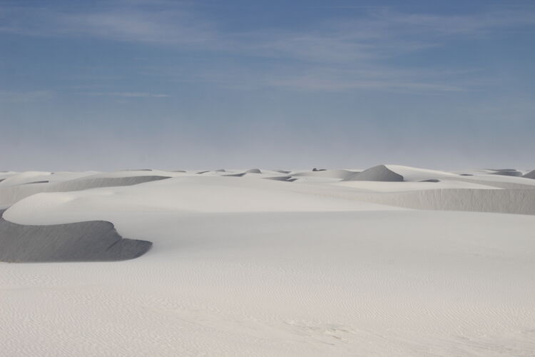
The "trail", such as it is, consists of a series of orange posts driven into the dunes every couple of hundred yards. The blowing and shifting sands quickly obliterate any tracks. Surely I'm not the first to hike it today but I can't see any footprints other than in the small valleys betweent the dunes that are protected from the wind. And plenty of wind there is. After 10 minutes I've already got a bandana strapped around my face to keep the sand from going up my nose. I'm definitely paying attention to those orange posts. It would be easy to get turned around in this kind of environment.


The sand is fine, white gypsum. A ranger later explains that this area was covered by a large lake in the last ice age; when it evaporated it left selenite crystals which over time decompose into the gypsum sand. The dunes are held in place by water below. During a particularly bad drought about 10 years ago, a lot of sand in the National Monument was lost to the wind. He says the sand plume could be seen on satellite images. There is concern that the park could eventually be destroyed by a severe enough drought.


I exit the dunes on the northwest corner of the trail. From here to the mountains is a long, flat plain which is the Alkali Flat. Through the blowing sand I can barely make out some kind of structure about a mile to the west. The ranger tells me that this is some kind of radar facility for the White Sands Missile Range. He's not sure if it's still in use. After a quarter-mile on the flat the trail turns back into the dunes.

I'm definitely burning through the water on this hike, but I prepared for the worst by bringing 4 liters. It is very hot and about as dry as could be. The high for today is supposed to be 98 degrees in Alamogordo; I would imagine it's a few degrees hotter out here. The deep sand makes for tough hiking in places. I quickly develop the habit of seeking out the sheets of hard-packed sand to walk on when they are available (which is not very often).


Back at the motorcycle I dump the accumulated sand out of my boots, change back into jeans, and ride to a spot where I can catch the sunset. Next to the trailhead parking lot there are some people sledding down the dunes with those cheap plastic snow sleds. Okay then, that must be a thing.


After a late dinner in Alamogordo I finally roll back into my campsite after 10pm. Looking up information on the park, I find that two French tourists died of dehydration on the Alkali Flat Trail a couple of years ago. Maybe the park service isn't being overly dramatic with their warning signs after all, although it's hard to imagine dying out there. A lot of things would have to go perfectly wrong to not be able to get out or at least call for help.
Stats for hike (Strava data):
Miles hiked: 5.1 mi
Elevation gain: 50 feet
Moving time: 1:45:26

