


Friday, September 15th, 2017
I'm not in the mood to break down camp this morning; I'll leave my stuff here and go hiking instead of trying to get a back country permit. More storms are in the forecast for this afternoon. After yesterday's hail attack, I'm paying heed to the weather report. I pick a longish hike from the list of trails on the back of my park map: Syncline Loop.

This trailhead is area is packed with people but they all seem to be here for the short hike up "Upheaval Dome" because I don't run into anyone on the trail until I'm near the halfway point.


I'm going counter-clockwise, the first 3 or so miles are a descent down washes and then a canyon, the beginning of which is marked by spectacular rock pillars of roughly the same height on both sides, like goalposts.


I run into a wall of rocks, the trail scrambles over and down them, then the canyon opens up wide. I see my first hiker of the day coming up the other direction. He's huffing and puffing, I'm definitely getting the easier part of this particular scramble by heading counter-clockwise on the trail. I wonder what awaits me on the other side, there will be at least the same amount of elevation gain to get back to the trailhead.


The heat ratchets up a few notches in the open canyon, there is no more hiding from the sun. I'm burning through water but I left with 4 liters so I should be fine.


At the midway point of the trail there is a spur that goes up to Upheaval Crater. I consider it but it's a dead-end up-and-back deal that would add 4 miles and who knows how much elevation to the hike. I'm not feeling up for it knowing I've already got a significant climb ahead of me. Another trail branches off from the same spot that goes down to the Green River. I would have to have all my gear and be ready for an overnight to take that one. I continue on the loop. Somehow I get off trail for a while by follwing a wash for too long, I missed the "exit". It's not hard to get back on track though, the path has to be heading up the same canyon and all I have to do is cross towards the other side until I stumble upon it again.


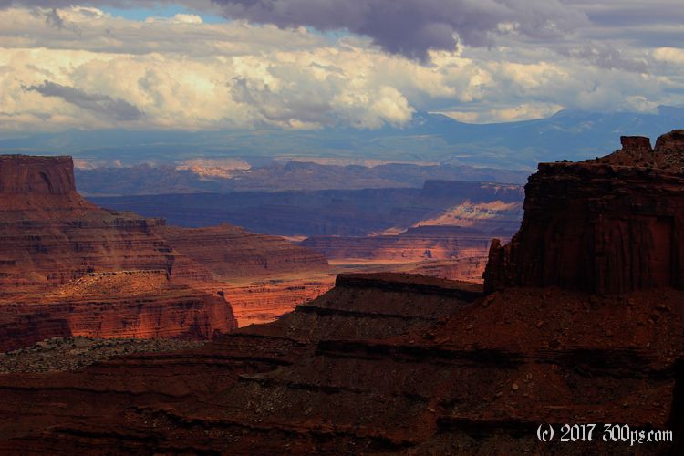
The last two miles are a very stiff climb back up the canyon wall(s). It's not a scramble though like the other side, here a rough staircase has been fashioned for most of the way. Nevertheless I'm thoroughly knackered by the time I get to the top. The views looking back down the canyon towards the Green River are spectacular. I keep turning around to snap another photo, I end up with about 20 of the same view from different elevations but I pare them down to just one:


True to the weather report, I can see ugly storms forming off to the west. I stop at the Green River Overlook to snap a few pictures but I'm not dallying.

A half hour after I return to camp the rain starts. Some gusts and a few downpours but no hail and the thunder is farther away; nothing like yesterday. Even so I'm confined to the tent for most of the evening.

Stats for hike (Strava data):
Miles hiked: 8.7mi
Elevation gain: 2,037 feet
Moving time: 3:39:56

