


Sunday, August 13th, 2017
Last night it rained... I don't think I've seen rain since Minnesota. The pitter-patter on the roof of the tent is reassuring after so much heat, smoke, and drought from North Dakota to here. The dryness was starting to have an apocalyptic feel to it, bringing nagging thoughts like climate change is destroying the environment, the end is near, etc... Well, here it is raining, perhaps not all is lost.
The distances involved in getting around this park are somewhat problematic. To get gas I have to drive 25 miles, when I get back I'm already 25 in the hole. The visitor center is 50 miles away, 100 miles round trip. The hikes aren't close by either, I'm looking at 40 to 80 miles round trip depending on the destination. On a good day Greta has a range of 200. End result is I'm making some long and frequent trips to refuel. Well, it gives me ample opportunity to ride the beautiful curves of route 20.

On the docket for today is Maple Pass, a hike that leaves from the Rainy Pass trailheads. The parking lot supposedly charges $5 but I don't pay, I think my annual parks pass gives me a free ride but I'm not sure. At any rate I'm not taking up a parking spot; I park on an angle next to another car. Off with the jeans, on with the shorts, and I'm off up the hill.


The start is fairly steep, at least at this end of the trailhead (Rainy Lake), through sub-alpine pine forest. As I get higher I start to glimpse the stunning views of the surrounding mountains. There are a fair number of people on the trail... I pass a couple who are coming down, the guy is carrying a toddler in his arms. I don't know about that, it's pretty steep and would be easy to trip on a root or a rock and fall.

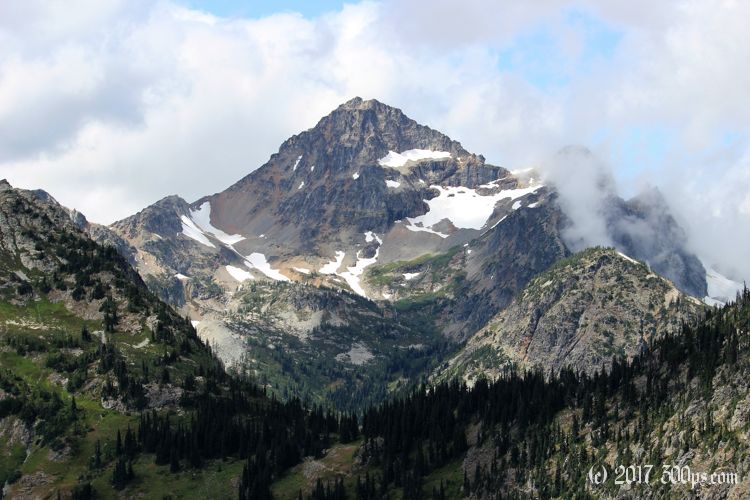
The views just get better and better the higher I get: snow-filled ravines, bright green and blue lakes, jagged peaks in every direction.


After reaching a first ridge I'm past the tree line and into an expansive meadow filled with wildflowers. I thought that was the the top but no such luck, the pass is still a mile or so above me, I will reach it by traversing a long series of switchbacks that wind through the wildflowers.


At the top of the pass I see some people going even higher, up a rocky knoll that sits on the pass like a head on shoulders. It's a scramble to get up, I have to put away my water bottle to free my hands for the climb. From here there is a commanding view of the mountains in every direction. To the west rain showers are moving in. I'm glad I brought my windbreaker and fleece because the temperature drops about 20 degrees when the sun is obscured by the clouds and it starts to sprinkle.


On the way down the other side of the pass (the trail is a loop), I run into a number of people who are woefully unprepared: wearing shorts and t-shirts, no packs and therefore no water, no warmer clothes, no food, no raingear... It's a busy trail so no imminent danger of serious harm but the families with kids should at least be somewhat prepared. South America taught me to respect the mountains, the weather can turn on a dime and often does.


I pass a guy who is running up the trail with his dog. I don't know how high he plans on going but I'm impressed, this is not an easy run. I tell him his dog has a big lead and he better pick up the pace if he wants to win the race.


I'm ecstatic to roll back into the campground to make a big dinner. There's a traveling cyclist who has moved into the campsite next to mine. I go over to tell him that the water pump is broken at the campground and ask if he needs water. It turns out he is deaf... I manage to communicate the above but it takes about 5 minutes of gesticulating and typing on the cellphone. Bicycle travel is hard enough as it is, doing it deaf must be quite the challenge. I assume he is doing the ACA Northern Tier route which follows route 20 through the park. He is heading east so he's just begun the journey. I'd like to talk to him more about what he's doing and share my bicycle travel experiences but the communication is so difficult and slow I give up quickly.
I get out of the tent late at night. The stars are amazing, just an explosion of points of light in every direction. A big meteorite goes shooting by. "Whoa" -- I spontaneously exclaim out loud.
Stats for hike (Strava data):
Miles hiked: 7.5mi
Elevation gain: 2,472 feet
Moving time: 2:40:25

