


| Distance | 41.50 kms | 26.10 miles |
|---|---|---|
| Climbed | 76 meters | 249 feet |
| Ride time (hours) | 4.18 | - |
| Avg speed | 10 kph | - |
| Distance | 222.14 kms | 137.94 miles |
|---|---|---|
| Climbed | 1,815 meters | 5,955 feet |
| Ride time (hours) | 19.49 | - |
Wednesday, October 18th, 2017
It took a while for the temperatures to cool down last night. I didn't get into the sleeping bag until around 3 or 4 in the morning. I get up at dawn, eat a few handfuls of trail mix for breakfast, and wheel the bike back to the road. I've only got 3/4ths of a liter of water to see me the 17 miles to Lake Alamo.


When I get about a mile from the lake the road splinters off into many tentacles leading to what appear to be unofficial campsites. A few them are populated with RVs. My path is dictated by RV-free two-tracks until I get to the water. I drop the bike, grab my filter, and set to work. I drink the first two liters about as fast as I filter them -- I must have been a bit dehydrated. I only fill up my two bottles that fit in the cages on the bike (2.5 liters); I don't plan on straying to far from the lake today. The lake, by the way, is an amazing explosion of life in the middle of the desert: there are ducks, geese, herons, cormorants, etc... plus jumping fish and even a few wild burros. It feels surreal arriving at such a place after the hot, sandy, barren stretch I just rode through.


The plan for the day is to see if I can get to the other side of the lake. The maps don't show any road that connects the two sides, either to the north or to the south, but I'm hoping I can push through whatever lies at the northern edge to connect the dots. It would save me about 100 miles of detour to the south.


I ride a couple of miles to the north on a very sandy road called Brewers Crossing. After a big downhill that I fishtail most of the way down the road ends at the edge of a riparian forest in the (mostly) dry northern corner of the lake bed. The vegetation is so thick it's like a jungle. I ride until I get to a marshy area, then I have to drag the bike across the mud, followed by dragging the bike across sand, followed by another dense jungle-like forest on the other side. I go up and down embankment in front of this wall of green but I can't find any road or decent trail like the one I started out on on the other side. I follow some tracks that cattle have made but every time I either end up in front of impassable brush or stacks of dead tree limbs. Either way, I'm not getting the bicycle through. My OSMAnd map shows a trail coming down from the other side. I bushwack my way to where the GPS shows me standing on the trail but there's nothing there but more thickets. The map line is suspiciously straight to begin with. Oh well, it's time to admit defeat: I'm not getting to the other side of the lake.


It's a bit demoralizing to have to retrace my steps, especially when those steps include crashing through thick brush, crossing a muddy river, dragging the bike over sandy embankments, and struggling up sandy dirt roads. Well I got a good workout at least.
Back up out of the lakebed and on the road I came down, I take a right onto a two-track that appears to go down to the shore. I'm thrilled with where it ends up: a circular mound with a flat top and fire ring that juts out into the lake. I drop the bike and jump into the water to clean off the day's sweat. After a good swim/bath and some water filtering, I lie down on my mat in the shade of a tree and take a snooze.

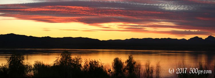
I have a fire while I make dinner which always makes the camping experience so much more enjoyable. To top it off I am treated to an exceptional sunset over the lake.


