


| Distance | 97.85 kms | 60.89 miles |
|---|---|---|
| Climbed | 1,550 meters | 5,085 feet |
| Ride time (hours) | 7.68 | - |
| Avg speed | 7.9 kph | - |
| Avg climb | 3% | - |
| Max grade | 15% | - |
| Distance | 25,548.76 kms | 15,875.41 miles |
|---|---|---|
| Climbed | 267,918 meters | 878,996 feet |
| Ride time (hours) | 1,805.76 | - |
Thursday, April 10th, 2014
There are two areas I want to see today: Goosenecks State Park and the Valley of the Gods. Since I want to head to Natural Bridges afterwards I'm going to have to do some backtracking to get everything in. First I climb up to the exit for Goosenecks Park, it's a road that dead ends at some deep meanders that the San Juan River has cut into the mesa. When I arrive I see that people are camping here, I should have tried to get here last night, but I just ran out of daylight. The views are spectacular.


Next up is Valley of the Gods. I backtrack towards Mexican Hat to take the eastern entrance into the valley, if I follow the dirt road all the way through the park it will take me out the western side onto the road that leads to Natural Bridges. I really enjoy this park, more so than Monument Valley, because there is hardly anyone out here and you can get really close to the monuments. The road gets difficult at times with some thick sand, steep grades, and washboard but nothing too dramatic. The toughest part is the last five miles climbing across a plain into the wind to get to the western exit.


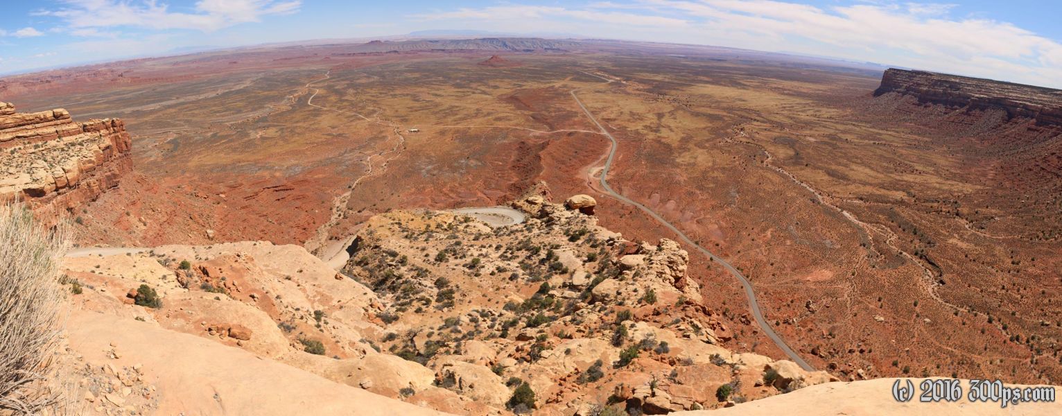
When I get back onto the pavement heading northeast it looks like the road runs straight into a cliff. I can't see the switchbacks yet but I suspect there will be a bunch of them, and the road doesn't disappoint. The pavement disappears for the bulk of the climb. I get some encouraging words from a few cars descending in the other direction, always a plus. At the top I am treated to a spectacular view of the Valley of the Gods to the left, Monument Valley to the right, and the mountains behind Mexican Hat dead ahead.


I have climbed up to a new mesa at around 7,000 feet altitude. The landscape changes to cedar forest instead of desert. The wind is helping me up here, I fly along for a good twenty-five miles or so until it becomes time to think about camping. The water situation is a problem again... I'm almost out and it looks like there is nothing up here until I come to a BLM ranger station. It's closed and no one is around. I'm wondering about my next move when a ranger pulls up; I ask him for water and he sets me up. Now I'm free to go look for a spot to camp. I get off the pavement onto a two-track dirt road and ride west for a few miles until I find a nice secluded spot to make camp.


After setting up I hike another mile west to get a glimpse of the sunset. I sit on the edge of a canyon to enjoy the sight.


I make dinner back at the campsite and enjoy the stars with a cup of coffee. I see a massive flaming meteor, a nice end to the day.

