


| Distance | 88.74 kms | 55.30 miles |
|---|---|---|
| Climbed | 791 meters | 2,595 feet |
| Ride time (hours) | 8.07 | - |
| Avg speed | 6.8 kph | - |
| Avg climb | 3% | - |
| Max grade | 21% | - |
| Distance | 26,438.44 kms | 16,427.81 miles |
|---|---|---|
| Climbed | 275,962 meters | 905,387 feet |
| Ride time (hours) | 1,871.85 | - |
Friday, April 25th, 2014
Miles pushing the bike: 2.5 (4.02 kilometers)
This morning is a retread of yesterday's sandathon, I start out by dragging the bike through thick sand back to the road where guess what's waiting for me: sand. I'm tired of using that word. Do they have dozens of words for sand in Saudi Arabia like the Eskimos have for snow? The wind is screaming from the south which will make it all the more interesting.


After some climbing the road takes a dive down to a long plain. I get going too fast, the panniers sound like machine guns on the washboard, then the sleeping bag goes flying off. The two-strap bungee that I use to secure it gets wrapped up in the wheel - fortunately it doesn't make me crash - but when I finally come to a stop I see that one of the straps has broken and gotten jammed in the mudguard. Lucky to not get a flat.


10 minutes later a van comes up behind me and stops. It's two employees of Outward Bound just come back from guiding a 3 day canyon trip for a bunch of people that flew in and out of an airstrip out towards the ranger station at Hans Flat. These two are driving the van back to Moab where they are based. They ask me if I want any of the left over food... why yes! They give me some salami, some roast beef, some apples, and a bottle of San Pelegrino. We talk for 15 minutes about my trip, their jobs, the region, etc... then it's back to work fighting the sand and wind. I have to walk the bike quite a bit on this stretch until the road swings north, giving me the wind at my back and that extra push I need to power through the sand when it gets thick.


Finally I hit route 24 and the pavement that I haven't seen since I left the town of Green River. The food gift is just enough to let me attempt Goblin Valley and the canyons beyond so I turn north on 24 for a mile before heading west again towards the state park. The wind is just brutal on this section, then even worse when the road turns due south.


I show up at the rangers' station completely flustered. The guy there tells me there is a water pump outside the station... awesome! but he thinks the road ends at Muddy Creek, he's not sure if it's possible to continue on to Hanksville on the other side. I pay 3 dollars to enter the park and spend a little while wandering around the goblin valley, a sort of bowl filled with bizarre gnome-like rock formations. Pretty cool actually, worth the 3 bucks. A guy tells me the weather is going to change tonight, rain on the way with cooler temperatures for the next week. This could get me in trouble if I try that back road to Hanksville but I'm going to give it a shot anyways. He also says he saw some touring cyclists on 24 headed this way.


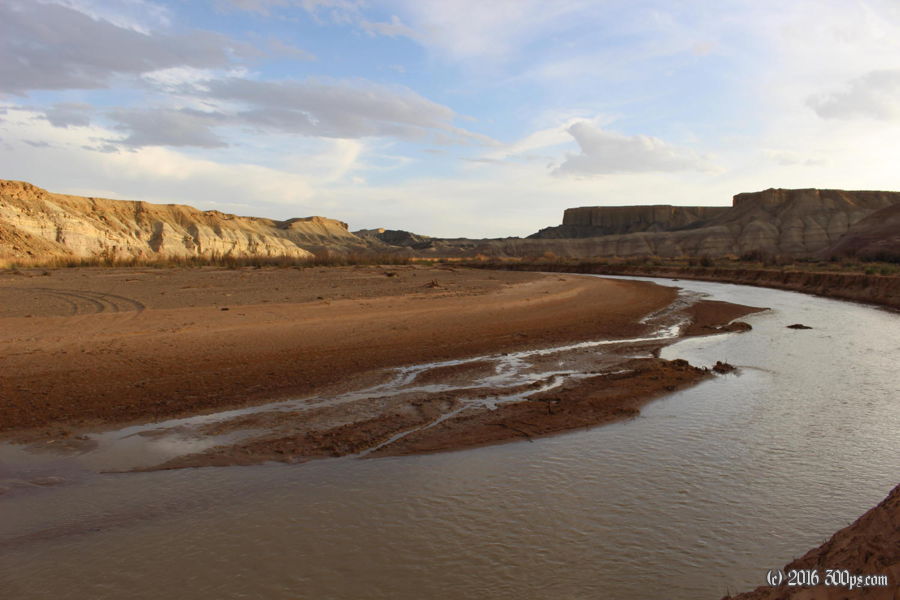
I dump my trash (thank God, I was carrying 3 days worth) and fill up my water bottles on the way out. I leave with 6 1/2 liters, should be more than enough to see me to Hanksville. I head down Horse-something Canyon against the blistering wind. The road is paved for 5 or 6 miles until I reach a slot canyon trailhead, then it's back to the sand and rock. This road is nothing short of spectacular, it winds through the canyon before climbing up through rock formations then dropping down into the valley that is home to Muddy Creek. It's getting late and I think about stopping to camp a few times but I want to cross the river today in case it swells up with tonight's forecast rain and gets too difficult to cross. The ranger told me that they had to go down and pull out a few 4x4's that got stuck there the other day.


I reach the river as the sun is starting to set. No way to get the bike across with all the stuff on it so I pull off all the bags and carry them across through thigh-deep water. Then I go back to carry the bike across. I reassemble everything on the other side and continue along a road that I'm not sure is the one that goes to Hanksville. While I'm riding a jeep comes up behind me, I ask if this is the right road, they say yes. We talk for a few minutes and they offer me a beer. Lots of offers for beer lately, everyone seems to think I need one.


I find a great campsite not long after that already has a big fire ring set up. I go collect wood then cook dinner on the fire. It's always a treat to end the day with a campfire, especially a day as good as this one.


