Hong Kong: Mountain-biking Lantau Island (Part 1)


Map
Loading...
Statistics for today
Distance 39.00 kms 24.23 miles
Statistics for trip to date
Distance 1,019.40 kms 633.18 miles
On this page

Friday, October 28th, 2016

Mountain-biking Lantau Island...well, more like hiking the mountains on Lantau Island while carrying a mountain bike. The trails are rough: lots of stone steps, unrideable rocks, etcetera... Loads of fun but some serious work, especially in this heat. Not for those looking for a casual ride; suspension and wide tires a must.

I have breakfast at my now-favorite restaurant where they invariably seat me with other random solo diners. Communication amongst us consists of "Zao" (good morning), "Xiexie" (thank you), and passing each other various and sundry items like chopsticks or sugar packets. I load up on eggs, toast, fried pork cutlet, and noodles; knowing my day is going to require some calories. Into the metro at 8am, which unfortunately coincides with the workday commute scrum towards the central business district on Hong Kong Island. We're packed into the train like so many "沙丁鱼" (sardines).

Click for a larger version of the picture
There must be more skyscrapers per square inch in this city than anywhere else in the world. The second I step out of the subway I'm instantly claustrophobic.
Click for a larger version of the picture
A series of walkways connects the downtown area. All very futuristic.
Click for a larger version of the picture

I make my way to Central Pier 6 for the ferry to Mui Wo, Lantau Island. It costs 28 HK dollars (about $3.50 US) for the "fast ferry" 35-minute boat ride across Victoria Harbour. There is an awful lot going on this harbour, some heavy-duty shipping.

Click for a larger version of the picture
Busy harbour.
Click for a larger version of the picture
Map of today's ride. Starting in upper-right corner. Down eastern coast, across the thin section in the middle, counter-clockwise around the bulb at the bottom, west/northwest to Pui O, then diagonally northeast accross the big bulb at the top to return to where I started in Mui Wo.

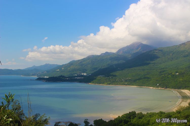
At the "Friendly Bike Shop" in Mui Wo I rent a mountain bike for $300 HK ($39 US) for the day. About 5 times more expensive than yesterday's bike but in my limited research I've surmised that a decent bicycle with suspension and disk brakes is needed for this route. Just a couple hundred meters from the bike shop I'm on a rough trail following the cliff next to the ocean. After a half-hour of this I'm completely drenched in sweat and will stay that way until the end of the day.

Click for a larger version of the picture
Looking down on Mui Wo from the mountain-bike trail. On the right is the pier where the ferry docks.
Click for a larger version of the picture
Looking back across Victoria harbour towards Hong Kong Island/Kowloon.
Click for a larger version of the picture
What the path is like: stiff grades (the camera never seems to do them justice), stone steps, occasionally a narrow spot to try and ride (rarely successfully with all the random rocks/roots/vegetation in the way).
Click for a larger version of the picture
Every so often there is one of these stands holding polls with rubber flaps attached. No idea what they are for.
Click for a larger version of the picture
Some nice little beaches in the coves.

My plan was to follow the coast south then clockwise around the end of the island, looping back to Mui Wo. The road is blocked at "Shap Long Chung Hau" by a portly policeman who says firemen are cutting down trees up the way. There are a bunch of mainland-Chinese hikers waiting as well, after 10 minutes we collectively give up and head west. Just a few kilometers toward "Pui O" I run into the entrance of the trail where I would have finished had I gone clockwise; I just follow it to do the loop counter-clockwise instead.

Click for a larger version of the picture
The hikers and I blocked by local law enforcement.
Click for a larger version of the picture
Map of the southern section of the ride.
Click for a larger version of the picture
Steep mountains everywhere.
Click for a larger version of the picture
Now on the western side of the island, following the cliff south, looking north here.
Click for a larger version of the picture
A rare calm section of the path.
Click for a larger version of the picture
Looking westish, China in the distance.
Click for a larger version of the picture
Looping in and and around these coves.
Click for a larger version of the picture
No snoozing on this trail, those are 3-foot dropoffs, instant faceplant if you're not paying attention.
Click for a larger version of the picture
Fabulous scenery.
Click for a larger version of the picture
Sections are like tree tunnels.
Click for a larger version of the picture
I believe this would be called "technical" in mountain-biker parlance. A 15% grade of rocks and stone steps.
Click for a larger version of the picture
Butterfly selection not quite as exciting as Taiwan.

To be continued...